Rare 17th century '˜chimney map' to go on display in Edinburgh


The artefact, discovered during the renovation of a house in Aberdeenshire, was handed to the National Library of Scotland after being rescued from a skip by builders.
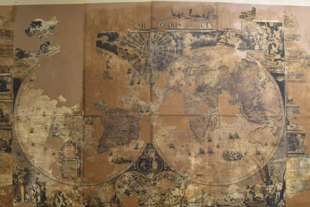
Researchers have now identified the piece as a 17th century wall map of the world produced by the Dutch engraver Gerald Valck, one of only three copies in existence.
Advertisement
Hide AdAdvertisement
Hide AdIt became known as the “chimney map” after it was first revealed last year to have been found stuffed up a chimney.
But experts now believe it was found under a floorboard during renovations in the 1980s to a house on the Castle Fraser estate near Kemnay, west of Aberdeen.
The National Trust for Scotland, which owns the castle, has started its own investigation to discover why such an important map came to be found where it was.
The near-ruined map was delivered to the library in Edinburgh bundled up in a plastic sack last year by Aberdeen schoolteacher and map enthusiast Brian Crossan.
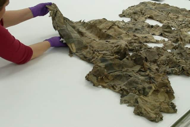
Experts have since removed the artefact from its original fabric backing, cleaned it, and reassembled it with a new paper lining.
Fragments that had fallen off, some much smaller than a postage stamp, have been reattached.
“This is a truly amazing piece of work,” said Mr Crossan. “I would never have imagined that this could have been done. I was sure the map was beyond saving and it’s great to see it once more hanging proudly on a wall for everyone in Scotland to see, instead of abandoned and out of sight.”
Advertisement
Hide AdAdvertisement
Hide AdThe restored map will be on display at the National Library in Edinburgh until April 17.
Clare Thomson, a conservator who worked on project, said she had strong doubts when she first saw the map about being able to salvage it.
“Never have I worked on anything as bad as this. It was so fragmented, some of it was just like confetti,” she said.
The map was separated into eight sections to be able to work on it and has now been re-assembled to appear as it was originally intended. Although significant sections have completely disintegrated and been lost, enough remains to be able to tell a fascinating story.
“Maps were largely symbols of power at this time,” said Paula Williams, map curator at the National Library. “They were very expensive to make and even more expensive, relatively, for people to buy. Whoever owned this map wanted to display their own power.”
As the map is Dutch, it represents a world view as seen from Amsterdam, complete with colonial ambitions. Australia, for example, appears as New Holland and the rivalry with their old enemy Spain is represented by a depiction of atrocities committed by Spanish invaders in South America.
Dr Esther Mijers, a lecturer in history at the University of Edinburgh said: “This map throws up more questions than it can answer. It would be wonderful if people wanted to do more research on the map and its story.”